
December Hurricane
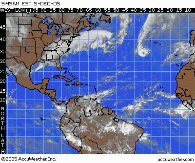
This is Epsilon 9:45 AM Dec 5, 2005. A perfectly formed cat 1 hurricane.
Look at that.
Have to blog this. Ergo, this blog will continue. Too much to blog, and I've turned into a blogger. You know you've turned into a blogger when you see something of interest and think " I have to blog this. :) What a wonderful venue this is. Everybody is blogging.
There is a December Hurricane Epsilon. It gained hurricane status on Sunday, December 4, 2005, after the end of the hurricane season on November 30th. . Amazing.
.......
fascinating.
its a perfectly formed hurricane. there are not supposed to be hurricanes in December.
fascinating.
......
peace and transcendence mes amis.
.....
so this is post 1 for December. lets see how the gematria plays out.
.....
News articles on Epsilon follow :
EPSILON MAINTAINS HURRICANE STRENGTHPosted: 5-DEC-2005 11:04am EST
by AccuWeather.com meteorologist Heather Zehr
As of 10 a.m. EST, Hurricane Epsilon was located near 33.6 north and 35.1 west, or about 545 miles west-southwest of the Azores. Epsilon is moving to the east-southeat at 8 mph and has maximum sustained winds of 80 mph with higher gusts. Hurricane-force winds extend 25 miles outward from the center, while tropical storm force winds extend up to 115 miles away from the center. The estimated central minimum pressure is 982 millibars or 29.00 inches.
Epsilon is maintaining hurricane strength despite being over waters below 80 degrees. Despite this, the prolonged exposure to cooler waters will cause the storm to slowly weaken over the next couple of days. Epsilon will turn more to the southeast as Monday progresses, due to high pressure growing stronger to the north and northwest of the storm. This will push the storm to the south and possibly even southwest by the end of the week. The storm will be lingering for a while yet.
The good news is that there are no other areas of tropical development to watch, and tropical systems usually do not develop this late in the year.
The hurricane season in the Atlantic Basin, which includes the Gulf of Mexico and the Caribbean officially begins June 1.-->
.....
my comments - what do i notice to keep in my quantum synchronicity warning be aware data folder in my old brainy waney? 982 millibars pressure. That's low. I learned all about millibars this past hurricane season, watching Katrina Rita and Wilma. Wilma broke the millibar pressure record. Wilma dropped to 882 milibars which broke the record set in the 1930's by Gilbert, I believe. http://weather.terrapin.com/wx/storm_show.jsp?storm=24A&dtype=ASCII&area=ATL. Link to show I'm not making up these numbers. Just pointing out, 982 where Epsilon is today, is pretty low on the millibar scale. hmmms. which I could calculate gematria like Rabbi Ginsburgh. cause numbers tell you stuff. that is why I love the mathematical interpretation Kabbalah encompases. we're being told, but we just don't understand. another thing to watch - the storm will linger for a while yet, the article says. so i need to watch it, maintaining my hurricane education that i'm receiving being here in fla. How long will Epsilon stick around? they dunno. ha. fascinating. snow all over, and a hurricane in the atlantic. there's snow back in jersey. fascinating. musing girl happily hmmms. hmmmmmmmmmmmm
.....
Next Associated Press Release - I'm not reprinting for personal gain just to present the info here in my blog in case somebody missed it.
Epsilon at hurricane force again in open Atlantic
Wind speed strengthens to 80 mph
ASSOCIATED PRESS
7:12 a.m. December 5, 2005
MIAMI – A tenacious Hurricane Epsilon strengthened slightly Monday as it lingered in the open Atlantic, posing no threat to land.
The 26th named storm of a record-breaking hurricane season had top sustained winds near 80 mph, up from 75 mph earlier in the day, according to the National Hurricane Center in Miami.
Despite being in cooler waters, Epsilon "refuses to weaken," hurricane specialist Lixion Avila said. "It means we still have a lot to learn about hurricanes."
But it was expected to turn southwest to areas with higher disruptive wind shear over the next day or two, he said, and "once it starts moving to the southwest, it's going to die."
The storm had been downgraded early Sunday to a tropical storm with sustained winds of 70 mph but unexpectedly regained hurricane strength of 75 mph. Epsilon first reached hurricane strength Friday and is the 14th hurricane of the season.
At 10 a.m. EST, the center of Epsilon's large eye was about 545 miles west-southwest of the Azores and moving east-southeast near 8 mph.
The Atlantic hurricane season began June 1 and officially ended on Wednesday.
Epsilon was only the fifth hurricane to form in December in more than 150 years of records, the hurricane center said. The latest that a hurricane has formed in the Caribbean was Dec. 30, in 1954.
.....
my comments - I like the word "tenacious". good word. "we still have a lot to learn about hurricanes". that relates my memory banks to Dr. Emoto, who says "we have a lot to learn about water". in both cases, we're being told we have a lot to learn. hmmm. love it. "unexpectedly regained hurricane strength". muses. all these hurricanes have done what is termed the unexpected. what is it unexpected? because we have to learn that we cannot outhink these manifestions. the storms do what we, humans, do not expect. what do we expect? I suspect that is the real question here. hmmmm.
.....
so it is the 14th hurricane.
the 5th december hurricane on record in 120 years.
so epsilon is the 26th named storm. we know what the gematria of 26 means. see post november blaagh ends. also, it is interesting that now that the names have gone into Greek Alphabet Letters, they have no gender. The other named storms are usually referred to by gender . fasinating. hmmmmmmm
http://www.livescience.com/forcesofnature/hurricane_guide.html#names
interesting link about hurricane names.
fyi.
http://www.nasa.gov/vision/earth/lookingatearth/hurricane_2005.html
nasa's link. great pics. play the animation - Nasa has each hurricane over laying . Great stuff for the visually inclined.
.....
fricky you have to comment cause you love hurricanes.
.....
here's the paradox, the contradiction. This is an update from bloomberg.com about the weather in NYC and environs. where i lived before i lived in fla, which is where i live now.
New York, Northeastern U.S. Face Snow as Winter Weather Nears
Dec. 5 (Bloomberg) -- New York and the city's suburbs are likely to get several inches of snow as storms move up from the south, bringing ``hazardous weather'' to the Northeast, U.S. forecasters said.
Snow is forecast for coastal states from North Carolina to Massachusetts. The snowfall will begin in New York later today and will continue early tomorrow, Bloomberg Radio meteorologist Kristen Kerouac said. The city may get 4 inches, and eastern Long Island as much as 8 inches (20 centimeters), she said.
``The heavy snow will fall late tonight on Long Island,'' Kerouac said. ``That will cause travel snarls on the morning commute, even though this will not be a blockbuster snow event.''
A snow advisory was posted for New York. A winter storm warning was issued for eastern Long Island, Connecticut, Rhode Island and Cape Cod, as well as for Philadelphia and parts of New Jersey, Delaware, Pennsylvania, Maryland and the Virginias, the National Weather Service said on its Web site.
The heaviest snowfall, up to 12 inches, will occur in Delaware, central Maryland and northeastern Virginia, with the potential to cause school closures, Kerouac said.
A low pressure system near Georgia is expected to track northeastward, dumping snow on the eastern seaboard, the weather service said in online advisories.
Philadelphia and surrounding areas may get 5 to 7 inches of snow, the weather service said. Washington and Baltimore may get 4 inches, and New Haven, Connecticut, faces as much as 6 inches, forecasters said.
``This amount of snowfall could cause significant and widespread travel problems,'' the service said. ``The weight of the snowfall could also cause some power outages. If you live in the warned area, it would be a good idea to check your winter storm survival kit. Also, if you must travel during the height of this storm, carry a winter emergency kit in your car.''
To contact the reporter on this story:
Alex Morales in London at amorales2@bloomberg.net.
Last Updated: December 5, 2005 08:03 EST
.....
so this is what we have.
somehow, the water temperatures in the Atlantic are able to remain warm enough to produce a hurricane.
yet the North wind blows.
:) ya gotta love it.

here is the newest update on Epsilon after the 3 o'clock update.
Hurricane Epsilon refuses to die in N. Atlantic
05 Dec 2005 16:44:15 GMT Source: ReutersMIAMI, Dec 5 (Reuters) - Hurricane Epsilon spun through the open Atlantic on Monday and defied forecasters' expectation that it would weaken as it moved over increasingly colder water.
At 11 a.m. EST (1600 GMT), the center of the storm was about 545 miles (880 km) west-southwest of the Azores, a group of Portuguese islands in the North Atlantic.
It was moving east-southeast near 8 mph (13 kph). Forecasters at the U.S. National Hurricane Center said they expected the hurricane to slow down, loop back to the southwest and dissipate over the next few days.
Epsilon did not threaten land but was still a hurricane with top sustained winds of 80 mph (130 kph).
The 14th hurricane of a record-breaking 2005 Atlantic hurricane season had alternately weakened and restrengthened, wobbling back and forth across the 74-mph (119-kph) threshold that categorizes a tropical storm as a hurricane.
Hurricanes need warm water for fuel and forecasters were perplexed at Epsilon's tenacity in the chilly north Atlantic, where it had been expected to fizzle.
"I am not going to speculate any more on the future intensity of Epsilon," hurricane forecaster Lixian Avila said in an advisory on the Miami-based hurricane center's Web site.
The six-month 2005 Atlantic hurricane season officially ended on Nov. 30, but December hurricanes are not unprecedented. Epsilon was the sixth to occur in December since record-keeping began in 1851.
The 2005 season was the busiest on record, with 26 tropical storms, besting the old record of 21 set in 1933. Fourteen of them grew into hurricanes, beating the record of 12 set in 1969.
The long-term average is 10 tropical storms per season, with six strengthening into hurricanes. For the first time, forecasters exhausted their annual list of 21 tropical storm names and turned to the Greek alphabet to name the last five, including Epsilon.
.....
they say it goes in cycles. but to meee it seeems that there is more to seeee than meeeets the e y e.
.....
posted by VickeB @ 12:11 PM
![]()
1 Comments:
my comment is, i'm continuing to watch this amazing manifestation of energy. sorry the posts are getting long. i'll put some short pretty ones back in.
also, snow in China they said they haven't had in 50 years. it is all connected to the water. the nasa link has the water vapor, and you can click on the animation. it is a good link.
thank you
Post a Comment
<< Home